

💦 Lac d’Annecy is a super place to head from 🗻 the Pays du Mont-Blanc for a stroll or a hike – perhaps for a bit of culture in the old town of Annecy, perhaps to escape the winter snow of the mountains, or perhaps for a FLAT stroll along the lakeside with a buggy.
You’ll find lots of flat walks around the lake, perfect for a buggy walk or with a youngster on 🚴♂️ a small pedal bike or push bike . . . and you also have a handful of easy family-friendly hikes which allow you to gain some altitude, like ⛰ the Roc de Chère or 💦 the Cascades d’Angon.
In this article, you’ll find 10 suggestions for strolls or short hikes around this iconic lake. I’ve listed them in a clockwise order around Lac d’Annecy from Annecy, and I’ll let you know when a buggy is NOT possible!
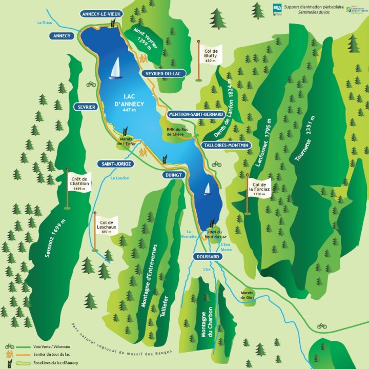
This 🗺 great map highlights the main villages around the lake, and the peaks overlooking the lake.
Colour Code for listings
🗻 Pays du Mont-Blanc
🇫🇷 Further France
Jardins de l’Impérial Palace, Jardins de l’Europe and the Old Town (Annecy)
When our boys were small we often found ourselves strolling through Annecy, often with relatives that were visiting.
If you start at 🌷 Les Jardins de l’Impérial Palace (you can 🅿️ park your car here), then it is actually a very decent walk into the old town (you might want to consider 🚴♂️ a push bike, small pedal bike or scooter if you have young kids, because it’s quite the distance with an aller-retour!). Here, you’ll find an aviary – 🐦 La Volière de l’Impérial – a playground and 🌳 the Parc Charles Bosson . . . you can also admire some the the year-round works (parcours pérenne) of Annecy Paysages.
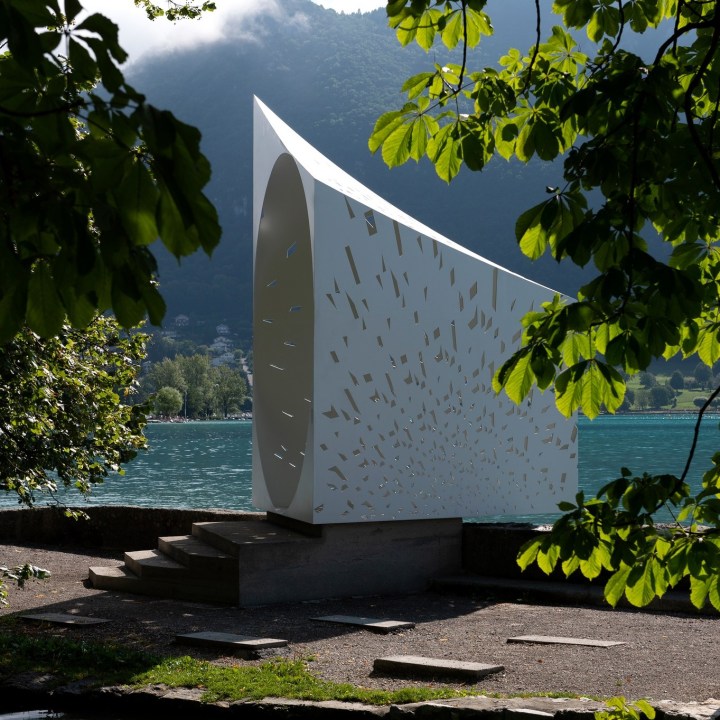

From here, you head across 🌷 the Jardins de l’Europe, with lots of green space for ball games, and you can stop at the very photographic Echappéé by Sylvie de Meurville, depicting 💦 Lac d’Annecy and the rivers and streams running into it . . .


You can cross the famous Pont des Amours, look out for 🦢 swans and 🦆 ducks around the Ile des Cygnes, and stop at the playgrounds here:

From here, you can head into the old town, which is delightful. Known as the Vénise des Alpes, because of its Thiou canal, Annecy even has its very own 🎭 Venitian carnaval in March! Please note that it can get very busy in the old town, especially over the summer months.
You can head up to 🏰 the castle, which is well worth a visit, or visit the Palais des Iles or the Musée de Film d’Animation.


Château de Menthon-Saint-Bernard and the nearby hamlets
A visit to the fairytale 🏰 Château de Menthon-Saint-Bernard, which has a superb location overlooking 💦 Lac d’Annecy and with views of 🗻 the mountains, is well worth a visit (winter hibernation until 1st April 2022). This medieval castle was lived in by the same family for 1000 years. A visit here can be combined with a short hike through the nearby hamlets of Ramponnet and Les Moulins . . .
distance: 4,5km;
time: 2h;
dénivelé: 134m;
note: upper section NOT possible with a buggy (in the woods) !
[ ⇒ more information on Lac d’Annecy Tourisme website here / castle website here ]


If you have time, you can head down to the charming village of Menthon-Saint-Bernard for a wander along the lakeside and in the streets.


Roc de Chère (Menthon – Talloires)
The ⛰ Roc de Chère is another nature reserve on 💦 Lac d’Annecy, a small 🌳 forested mount (200 hectares) located between Menthon-Saint-Bernard and Talloires.
You have different trail options, each well sign-posted, and each taking you through the forest and offering fabulous viewpoints across the lake.
Probably the best place to park is next to the golf course, at Echarvines : route du Golf, Talloires, 74290, Talloires-Montmin;

distance: 5,4km;
time: 2h;
dénivelé: 178m;
note: NOT possible with a buggy !
[ ⇒ more information on Lac d’Annecy Tourisme website here ]


On this hike, you’ll be treated to interesting rocky areas, forest for cabanes-making, amazing views across the lake and of the mountains . . . and you’ll find informative panels along the way . . .


Talloires – a stroll through the pretty village
Talloires is a pretty village located on the eastern coast of 💦 Lac d’Annecy. By wandering through the village, you can discover its history. For more information about Talloires, see here.
Be sure to stop at l’Abbaye, by the lakeside – Cézanne visited this historic hotel and painted his famous view on Dingt castle from here!
distance: 2,5km;
time: 2h;
dénivelé: 34m;
[ ⇒ more information on Lac d’Annecy Tourisme website here ]
 © montblancfamilyfun.com")
 © montblancfamilyfun.com")
 © montblancfamilyfun.com")

If you have the time, it is well worth heading with small or older children up to the 🌳 accrobranches above Talloires : Acro’Aventures Talloires – there is an area reserved for little ones, La Forêt des Sens . . . and you can watch the parapentes taking off.


Nearby, overlooking Talloires, you can also head to the pretty ⛪️ Ermitage Saint Germain.


Cascades d’Angon (Angon)
You have several good hiking options to 💦 the waterfalls, and here I’m highlighiting two: (1) one gentler from above the waterfalls in Vérel, (2) and one starting from below in Angon and passing through Rovagny . . . (you can also hike up to the waterfalls from Talloires, on a relatively easy path through the forest).
⚠️ note: sections of both of these hikes pass by VERY dangerous cliffsides. It is important that you DO NOT let children hike ahead, and that you hold firmly to little hands! The last section of the hike, you are walking on slippery terrain, with cables and barriers in place to help keep you steady. This section is partly carved into the cliffside, so NOT possible with baby backpacks (otherwise little heads will be hurt!). Kids will love this section, but keep them close! It’s important to wear footwear with good grips (and attachable small crampons if necessary).

Cascades d’Angon from Vérel (Vérel)
You can hike UP to 💦 the Cascades d’Angon, but this does require a certain amount of dénivelé, and so this particular suggestion is suitable for families (it starts from above the waterfalls). It’s a pretty hike, with views of ⛰ the Massif de la Tournette and ⛰ the Dents de Lanfon.
You can either walk a boucle, pass the Pont des Fées, or you can do the shorter aller-retour straight to the waterfalls.
The highest of the waterfalls measures 65m, and comes from the torrent coming down from the Dents de Lanfon and the Massif de la Tournette . . .
You can park at: chemin de La Closette, Montmin, 74210, Talloires-Montmin;
distance: 4,3km;
time: 1h30;
dénivelé: 259m;
note: NOT possible with a buggy ! It is not advisable to do this hike after rainfall, when the path can be very muddy and slippery!
[ ⇒ more information on Lac d’Annecy Tourisme website here ]


 © montblancfamilyfun.com")
Balade du Pont des Fées (Angon)
This hike is a bit tougher, so ideal for older children, and is outlined well on the website Randos en Famille . . .
” Jolie randonnée qui alterne entre forêt, villages, magnifiques vues sur le lac et cascade avec un dénivelé fort au départ puis une boucle sans difficulté. La cascade d’Angon est un bijou de fraîcheur et impressionnera petits et grands! ” / ⇒ see here for more information;
The hike is recommended in springtime, with the spring melt!
distance: 4,2km;
time: 2h10;
dénivelé: 380m;
note: NOT possible with a buggy ! It is not advisable to do this hike after rainfall, when the path can be very muddy and slippery!


La Réserve Naturelle du Bout-du-Lac in Doussard
Down at the southern tip of the lake, you’ll find 💦 the réserve naturelle du Bout du Lac, a humid zone home to many unique 🐸 animals and 🌾 plants. There is a trail through the reserve (partly wooden passerelle), which is possible with a buggy or ♿️wheelchair (1,6 km of the trail). You’ll find 🗺 informative panels throughout, so that you can learn more about the history of the nature reserve, including 🏰 the tour médiévale de Beauvivier (now an observatory), as well as learning more about the flora and fauna. Be sure to take binoculars for bird spotting.
distance: 3,2km;
time: 1h;
dénivelé: 23m;
[ ⇒ for more information about this stroll, see separate MBFF article here ]
 © montblancfamilyfun.com")
 © montblancfamilyfun.com")
 © montblancfamilyfun.com")
 © montblancfamilyfun.com")
 © montblancfamilyfun.com")
 © montblancfamilyfun.com")
Sentier des Roselières (Saint-Jorioz)
Departing from the pretty port of Saint-Jorioz, you’ll find 🌾 the Sentier des Roselières, a stroll along the lakeside, which takes you through the protected reed beds! A themed walk, with 🗺 informative panels along the way, you’ll learn about the 🦆🐟 aquatic wildlife living amongst and depending on 🌾 the reeds. This stroll is an aller-retour, so you can head back when you want.
The stroll is suitable with a buggy, as it is flat, and it is also acceptable for 🚴♂️ small bikes or push bikes (not trottinettes, the path is too rough, and not large bikes, as this is NOT a bike path!).
Your walk takes you towards 🏰 Dingt castle, immortalised by Cézanne . . .

[ ⇒ for more information about this stroll, see separate MBFF article here ]
distance: 4,5km;
time: 1h30;
dénivelé: flat;


In Saint-Jorioz, be sure to stop off at ⛰ the beach or at Criq’Aventures!
Le Marais de l’Enfer (Saint-Jorioz)
This boucle crosses 🌿 the marais (wetland) and runs alongside the lake, with pretty views of 🗻 the mountains and 🌾 the reed beds of the lake. Be sure to take binoculars for bird spotting!
distance: 4,1km;
time: 2h;
dénivelé: 18m;
[ ⇒ more information on Lac d’Annecy Tourisme website here ]

Tour du Plateau du Semnoz
🌿 Le Plateau du Semnoz allows wonderful views over the lake on a clear day, as well as views of 🗻 the Mont-Blanc, la Tournette, 🗻 les Aravis and les Bauges. You’ll be hiking in mountain pastures, so lots of 🐄 cows to see!
If you drive up from Annecy, be sure to stop at 🦌 the Parc Animalier de la Grande Jeanne – you’ll get to see some deer.


You can 🅿️ park at the route du Semnoz, 74540, Viuz-la-Chiésaz . . . you also have the Jardin Alpin du Semnoz and the luge d’été . . .
After the hike, you can drive back through Leschaux – it’s a pretty drive, bringing you into Saint-Jorioz or Sevrier.
distance: 5,2km;
time: 1h40;
dénivelé: 110m;
[ ⇒ more information on Lac d’Annecy Tourisme website here ]


La petite boucle du Taillefer : le Mont Gerbet (Taillefer)
La petite boucle du Taillefer par le Mont Gerbet is an easy hike, with views over the lake and the pretty 🏰 Duingt castle. The first part of the walk to the belvédère takes 10 minutes, and the second part of the hike up to the plateau . . . follow the yellow arrows!
distance: 3,2km;
time: 1h20;
dénivelé: 260m;
note: NOT possible with a buggy and not advisable after rain !
[ ⇒ more information on Lac d’Annecy Tourisme website here ]

For more ideas for family hikes around Lac d’Annecy and in the environs, see Lac d’Annecy Tourisme website here;


2 thoughts on “10 family strolls & easy hikes around LAC d’ANNECY”