

This is the follow-up article for 10 ideas for 🍁 autumn stroll with young children 🏔 au Pays du Mont-Blanc (see here).
Autumn is certainly arriving, and I love this season of 🍁 burnt seasonal colours adorning the trees and covering the ground accompanied by early ❄️ snow powdered on the nearby 🏔 summits!
And so, here are some ideas to head out and enjoy those 🍁 dazzling colours . . .
[ disclaimer: you must always keep in mind that in autumn hunting season is upon us (Monday, Tuesday, Thursday, Saturday & Sunday), from September ⇒ January, so DO pay heed to signs and always wear bright clothing! / see here for more details ]
[ ⇒ for further ideas for 🍁 PARKS & GARDENS in autumn, see separate MBFF article here ]

Colour code for listings:
🇫🇷 Further France
🇨🇭 Switzerland
🇮🇹 Italy
FURTHER FRANCE
Val d’Arly
Sentier des Arpelières (Crest-Voland or Les Saisies)
[ note: this trail will SHUT for winter hibernation from 24thOctober 2021 ! ]
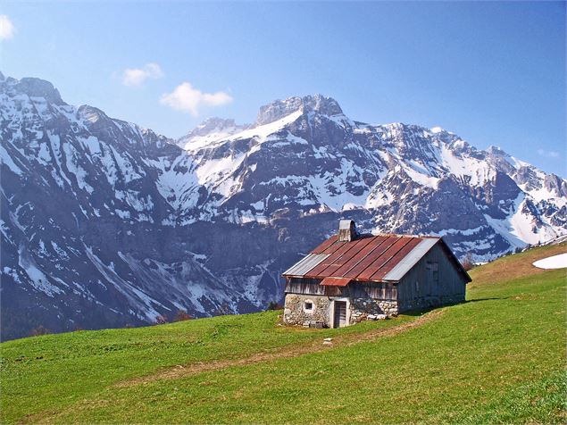
I have hiked all over the world, but – hand on heart – 🍁 the autumn colours and 🍄 the magical nature of the terrain on this hike make this one of my all time favourite 🍂 autumn strolls! This hike is easily accessible for the whole family, and it is annotated in a way to keep little ones engaged from start to finish!
The Val d’Arly website describes the hike as ” un petit air de Scandinavie flotte sur la Réserve Naturelle Régionale de la tourbière des Saisies, un site naturel protégé de 290 hectares, et vieux de 10 000 ans “. Having hiked a little bit in 🇳🇴 Norway and 🇮🇸 Iceland, I can see from where hails this comparison!
The Réserve Naturelle Régionale de la tourbière des Saisies is located on le plateau du Lachat, between 🗻 the massif du Beaufortain and 🏞 the vallée de l’Arly, between 1550m and 1718m altitude, and it is a relic of the last ice age! The Sentier des Arpelières was built in the heart of this reserve, and it allows you to discover the fragile biodiversity of this peat bog wetland, by using the wooden walkways: 🌿 high altitude sphagnum moss, 🌱 moorland, 🌳 and forests, dragonflies, 🦉 mountain owls and the very rare black grouse, to name a few . . .
🗺 distance: 1,2km ⇒ 3,6 km (a longer or shorter trail available);
⏱ timing: 1h30 hour to 4 hours (depending on trail);
⛰ dénivelé: +/- 100m;
👨👩👧👦 buggies: NOT possible with a buggy, so take a baby-carrier;
🚙 how to get there:
- from Crest Voland, follow the D71a (towards Les Saisies) and pass la Croix des Ayes. A bit further along, on the right, is the pannel designating the start of the sentier (park by bridge on Nant Rouge river);
- from Les Saisies, head towards Crest-Voland, drive down past 3 bends in the road and find the pannel on your left;
- from Le Cernix, follow the route forestière de la Palette and leave your car at the obligatory car park; then walk to start of hike;
⇒ more information: here and here (carte d’itinéraires pédestres Val d’Arly on sale at Office de Tourisme);


 @ montblancfamilyfun.com")
 @ montblancfamilyfun.com")

 2019 @ montblancfamilyfun.com")
 @ Stefan Haag")
 @ Stefan Haag")
Cluses Arve & Montagnes
MBFF has really enjoyed doing several of Cluses Arve & Montagnes’ 🗺 jeux d’aventure over the last couple of years (see here for full list) . . . MOST of these shut after September, when the hunting season kicks in, but a few or them still operate until the winter season. Here are a couple of suggestions:
Sentier du Colporteur Nature (Nancy-sur-Cluses)
On this family trail, you follow 🦉 Eliot, the little owl, and he will help you discover the secrets of 🌳 the forest, local patrimoine and the life of 🎒 the colporteurs (local peddlers), along a sentier ludique set across 10 pannels. The 🗺 sentier ludique was made in conjunction with the 🦌 Centre de la Nature Montagnarde (Sallanches) and is aimed at children 4+ years. Pick up information from the tourist office in Cluses.
🗺 distance: 3,5km;
⏱ timing: 1 to 2 hours (depending on time spent at each explanatory pannel);
⛰ dénivelé: 130m;


Click to access CAmT_FICHE_RANDO7_ColPORTEUR_2020_web.pdf
Parcours d’Orientation in Le Reposoir & Col de Romme
Le Reposoir is a lovely mountain village, and MBFF discovered it a couple of winters ago, by doing the 🗺 parcours d’orientation L’Oeuf de Plume la Gypaète. There is also a parcours here aimed at younger children that my son had already done on a garderie visit!
[ ⇒ read about MBFF’s visit to Le Reposoir here ]


Plateau de Cénise and Lac Bénit (Mont-Saxonnex)
Mont-Saxonnex is a pretty mountain village, and one that you have most probably glimpsed from 🛣 the Arve valley motorway below, from where is visible its ⛪️ iconic church; it sits on a promontory and overlooks the valley below!

- Le plateau de Cenise – this plateau, above the Rochers de Leschaux, has a view of the Chaîne de Bargy and dotted across 🌱 the meadow are some 🏚 chalets d’alpage, now residential, but testimony to a rich pastoral past. This is also the home to the tétras-lyre / it is a great, wide space, perfect for running! / more information here;


- 💦 Lac Bénit (1450m) – nestled under ⛰ the Massif de Bargy, at the foot of the cirque d’Encrenaz, is this small glacial lake. There are various hiking routes that will get you to the lake (the Télésiège de Morsullaz only operates over the summer months). Tales of 🧚♀️ fairies and legends abound about this “sacred lake” / more information here / shortest hiking route from 🅿️ Parking du Bété (1h30 and +/- 160m dénivelé), but a prettier hike would be from 🅿️ Télésiège de Morsullaz, as from you arrive to breathtaking views down over the lake;


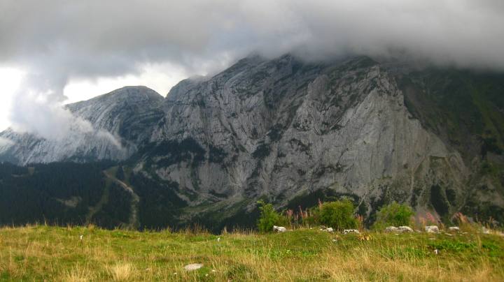
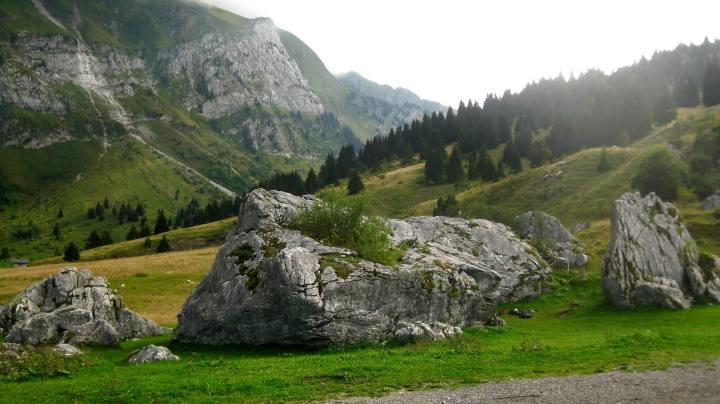
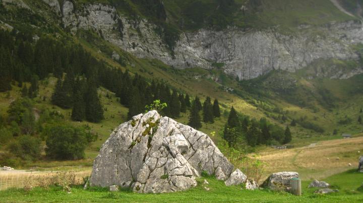
Between Mont-Saxonnex and the Plateau de Cenise, you’ll find the 🧗♂️ Blocs de Morsullaz – this is a beautiful bouldering site, with big blocks scattered across a meadow! There are also picnic tables available, and the Auberge Pointe du Midi restaurant across the road / disclaimer: take proper precautions and equipment if climbing here! / more information here / map;
Annemasse environs
Le Salève
[ note autumn 2021: the 🚠 Téléphérique du Salève is currently SHUT for a huge 2 year renovation programme, but you can still drive up onto ⛰ the Salève or hike up ! ]
A few autumns back now, we decided to head up on the 🚠 Téléphérique du Salève, to explore this ⛰ iconic mountain, popular with Annemasse and Geneva locals, with fabulous views over 💦 Lac Léman and its Jet d’Eau!
more information: 🚠 Téléphérique du Salève and walking options;
[ good to know: learn more about this incredible mountain at the fabulous Maison du Salève in Présilly ]


Vallée du Giffre & Vallée d’Aulps
Sixt Fer à Cheval (Vallée du Giffre)
Sixt-Fer-à-Cheval is one of my favourite destinations to hike, and 🍁 autumn is a glorious time to visit, with 🍁 the autumn palette set against 💦 the roaring waterfalls and cliffs! Sixt-Fer-à-Cheval is the largest alpine “cirque” (a natural amphitheatre) and the largest nature reserve in Haute-Savoie! There are lots of different hiking possibilities, with the best-known being to the « Bout du Monde » (3h aller-retour; see here). . . For younger hikers, you might consider the boucle « Le Fond de la Combe » (45 minutes), possible with a buggy (see Le Chablais des enfants here), the « Boucle de Giffrenant » (1h30) or simply a visit to the majestic Cascade du Rouget (you can park next to this!).
The village of Sixt-Fer-à-Cheval is also very quaint, and one of the Plus Beaux Villages de la France.
« Le Fond de la Combe »:


Le Boucle de Giffrenant in autumn 2020:


 © mont-blancfamilyfun.com")
 © mont-blancfamilyfun.com")


Au Bout du Monde by Xavier Lesne:

Sixt-Fer-à-Cheval is the land of 💦 waterfalls (there are 30!), and these are at their most impressive during the spring melt, but in autumn you’ll have 🍁 the stunning colours! The most accessible to view (you can park next to it!), is 💦 La Cascade du Rouget:


🍁 more autumn colours in Sixt-Fer-à-Cheval . . .


Les Anciennes Gorges des Tines (between Sixt-Fer-à-Cheval and Samoëns)
MBFF hiked in 🌲 Les Anciennes Gorges des Tines for the very first time last summer, and I said to myself at the time how lovely it must be to hike there in the 🍂 autumn (albeit with due care, as it is slippery under foot when wet, and there are steep parts and ladders to climb up or down!). The hike is spectacular, and you feel like you have discovered a land lost in time, like you might bump into a dinosaur round the next bend! It will take you about an hour to hike, and is superb for families (though not suitable for tiny ones, as there are ladders and sharp drops; I’d recommend 5+ years, and DO not let children run ahead!). You can hike the boucle in either direction . . . we opted for the clockwise route, though this did involve walking DOWN ladders within the gorges, so if you’d rather walk UP ladders, then you’d be advised to hike anti-clockwise (you’ll still have a small section dowhill with ⛓ a handrail, back down to the Bord du Giffre);
🗺 distance: 2,5km;
⏰ timing: 1 hour;
⛰ dénivelé: +/- 90m;
🗺 more information and map: OT Morillon and pdf document;
👨👩👧👦 buggies: NOT possible with a buggy!

Lac de Montriond (Vallée d’Aulps)
💦 Lac de Montriond, located in the Vallée des Aulps and in the Geopark Chablais, is the largest alpine lake in Haute-Savoie: 33 hectares (or 25,000 to 35,000m2, depending on water level!), 1320m long and 253m wide! And it is 19m deep at its deepest point!
The lake is known for its pristine location, nestled under majestic cliff faces, and for its calm waters. And yet, under its calm waters, 💦 Lac de Montriond hides a tumultuous geological history! The lake was formed after a part of the NW side of the Nantaux mountain fell in a landslide around 4500 years ago – this caused a dam to build up on the torrent which was running at the bottom of the valley, and the lake was hence formed.
In ☀️ summertime, you’ll find watersports and other activites, ❄️ winter brings diving, and 🍂 autumn brings . . . lovely strolls!
You have several options for for family hikes here, and you’ll find picnic tables too:
- 💦 tour du Lac de Montriond – this is a decent hike, as it is 3km or so to hike around the lake!

- 💦 Dranse river trail – this river trail extends from Montriond to Saint-Jean-d’Aulps, but you can choose how much you walk! You can hike along the path with a buggy, or take bikes!

- 💦 Cascade d’Ardent – a site classé, la Cascade d’Ardent can be reached by walking through the forest / more information here;


And, if you head to Montriond over the Toussaint holidays, be sure to look out for 🎃 the Halloween activities !
Lac d’Annecy
💦 La Réserve Naturelle du Bout du Lac (Doussard)
Have you ever visited Doussard, at the bottom of 💦 Lac d’Annecy? MBFF has been there a handful of times, though normally in summertime, when we’ve enjoyed a swim, as well as a visit to the nature reserve!
🍁 Autumn is beautiful here too, and you can walk through the nature reserve – La Réserve Naturelle du Bout du Lac – part of the trail taking you across wooden walkways, with a bridge to cross . . . AND you can walk this with a buggy! / see here for more details;
🗺 distance: 2,6 km;
⏱ timing: 45mins;
👨👩👧👦 buggies: YES!
⛰ dénivelé: +/- 43m;
🗺 map: Google Maps here;
more information: here;
 © montblancfamilyfun.com")
 © montblancfamilyfun.com")
 © montblancfamilyfun.com")
 © montblancfamilyfun.com")

« Le Festival des Cabanes » (Les Sources du Lac d’Annecy)
🏚 Le Festival des Cabanes is a set of architectural installations (cabanes) set in 🌳 nature, located around the Sources du Lac d’Annecy. You’ll find several cabanes around Faverges and Doussard; and the festival runs until 🗓 1st November 2021 / see here;
💦 nearby activities: while visiting the cabanes, you could also stop off to see 💦 the Grotte et Cascade de Seythenex, a UNESCO site located at the entrance to ⛰ the Parc Naturel du massif des Bauges, at the foot of ⛰ the Massif de la Sambuy. This is the only underground cave system open to the general public in Haute-Savoie! / 🗓 open until 1st November 2021 / see here for more information (address: 576, route des Grottes, 74210, Faverges-Seythenex);


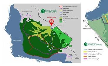
💦 La Réserve Naturelle du Roc de Chère (between Menthon-Saint-Bernard and Talloires)
⛰ Le Roc de Chère, located beween Menthon-Saint-Bernard and Talloires, is a small rocky and 🌳 forested outcrop, measuring 200 hectares, and it overlooks the blue waters of 💦 Lac d’Annecy. There are some lovely hiking trails here and exceptional views of the lake and neighbouring mountains.
The nature reserve, created in 1977 and measuring 68 hectares, occupies a part of ⛰ Roc de Chère, and is abundant in varied flora and fauna! / FB page for more information;
NEW! – 3 panneaux pédagogiques explaining geology, flora and fauna!


SWITZERLAND
Geneva botanical gardens
The MBFF tribe members are huge fans of the 🌷 CJBG – Le Conservatoire et Jardin Botaniques de la Ville de Genève, and we have regularly visited in autumn!
The 🌷 original botanical gardens in Geneva were founded by Augustin-Pyramus de Candolle in the early 19th century and they were located in 🌳 Le Parc des Bastions (which was then empty, marshy terrain!). As the collection of 🌿 plants and trees grew, the arboretum was moved to the present area, above rue de Lausanne, in 1904.
Today, you can wander the grounds and enjoy:
- 🌵 green houses;
- 🏦 Japanese gardens;
- 🗻 alpine gardens;
- 🌿 Terre de Pregny;
- 🌈 a super playground . . .
- 🦚 animals;
- . . . and much more!
[ ⇒ for more information, see MBFF article here ]


Bisse du Trient (Col de la Forclaz)
This is a great family hike, following the course of 💦 the old irrigation channel from 1895 (which brought water from the Glacier du Trient to the Col de la Forclaz), and before that transported blocks of ❄️🧊 ice for delivery throughout 🇨🇭 Switzerland and 🇫🇷 France! 🗺 Along the way is 🗺 a parcours ludique, and at the end of the walk you are rewarded with a view of ❄️ the Trient glacier (the buvette shuts in September: La Buvette du Glacier).
🗺 distance: 6,5km aller-retour;
⏱ timing: 1h30 aller-retour;
⛰ dénivelé: +/- 112m;
👨👩👧👦 buggies: YES, though a bumpy ride (I’d opt for a baby-carrier!);
more information: here;
[ NB: if small children are walking, it is imperative to hold their hand at all times (and not let them run ahead!), as there is a steep drop ]


ITALY 🇮🇹
[ I’m adding these suggestions, but please remember that any visit to 🇮🇹 Italy over +72 hours will require a certificate of Covid-19 negative test! Perhaps a visit to plan for autumun 2021? ]
Val Ferret
🏞 Val Ferret is a valley especially popular with 🏔 Pays du Mont-Blanc folk for ❄️ winter ski de fond, and summer hikes, biking and fishing . . . 🏞 Val Ferret is located in the shadow of the massif Grandes Jorasses, with its iconic Dent du Géant being mythical in the world of alpinism.
Luckily for the less alpine, there are numerous 🍂🍁 autumn hikes leaving from this beautiful valley, not least a stroll along the 💦 river La Doire de Ferret (and affluent of the 💦 Dora Baltea that runs through the Aosta Valley) up the valley from Planpincieux!


Val Veny
🏞 Val Vény is one of most beautiful alpine valleys! It was carved out by the Glacier de Miage et de la Brenva, and borders with 🗻 le massif du Beaufortain.
Just walking through the valley in autumn, up towards the Lago di Miage, is stunning!


2 thoughts on “10 MORE ideas for AUTUMN FAMILY HIKES & STROLLS with small children (beyond le Pays du Mont-Blanc)”